


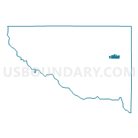
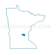
Zimmerman P-1, Sherburne County, Minnesota
About
Outline

Summary
| Unique Area Identifier | 604398 |
| Name | Zimmerman P-1 |
| County | Sherburne County |
| State | Minnesota |
| Area (square miles) | 1.40 |
| Land Area (square miles) | 1.30 |
| Water Area (square miles) | 0.10 |
| % of Land Area | 92.83 |
| % of Water Area | 7.17 |
| Latitude of the Internal Point | 45.44823860 |
| Longtitude of the Internal Point | -93.59792230 |
Maps

Graphs
Select a template below for downloading or customizing gragh for Zimmerman P-1, Sherburne County, Minnesota


Neighbors
Neighoring Voting District (by Name) Neighboring Voting District on the Map
- Livonia Twp. P-1, Sherburne County, MN
- Livonia Twp. P-2, Sherburne County, MN
- Zimmerman P-2, Sherburne County, MN